
As the 2026 southwest monsoon begins its withdrawal, its overall performance reveals a complex and nuanced picture.
Cumulatively, from June 1 to September 23, 2026, India recorded rainfall below the Long Period Average (LPA). While north-central and west-central India experienced near-normal conditions, several other regions recorded persistent rainfall deficits, according to data from the India Meteorological Department (IMD).
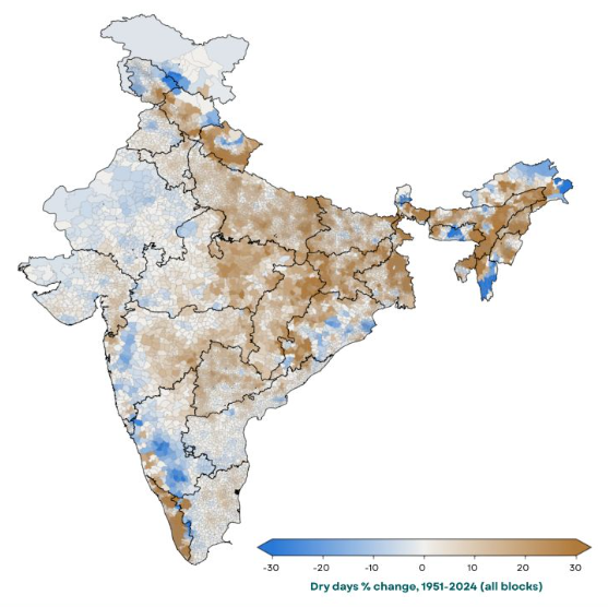
However, the most critical risk signal lies beneath these seasonal aggregates. Long-term climate analysis indicates an increase of up to 30% in dry days (defined as days receiving less than 2.5 mm of rainfall) across key parts of the region. Crucially, this hotspot directly overlaps with the monsoon core zone.
For rice and other Kharif crops, the central question for risk managers is no longer simply “How much rain fell?” but rather “How was that rain distributed across critical growth stages?”
Quantifying how prolonged dry spells impact crop establishment, soil moisture, and final yields, and integrating these climate signals into localized risk models, is now essential for building agricultural resilience and safeguarding capital.
Source: India Meteorological Department (IMD); Climagro Analytics analysis.
Explore Related Research
Access Climagro Analytics' detailed climate risk profiling, block-by-block assessments, and full policy reports to understand local hydroclimatic vulnerabilities.
View Monsoon Hydroclimate Report