Agriculture Risk Intelligence Platform
CropRisk.ai is an AI-driven agricultural risk platform that estimates crop and location-specific climate risks by integrating climate stress metrics, crop response models, and field management data - enabling predictive assessment from season-level outlooks to long-term projections to 2100.
AI-Powered Predictive Intelligence for Agriculture Risk
CropRisk.ai combines crop-specific AI/ML models with scientific crop-growth simulations to estimate climate risk at the intersection of where a crop is grown, how sensitive that crop is to climate stress, and what climate conditions are projected for that location.
Unlike generic climate indices, CropRisk.ai accounts for crop phenology, growth stages and field management practices - giving risk estimates that are directly actionable for farmers, lenders, insurers and agribusinesses.

How CropRisk.ai Works
Four steps to estimate crop-specific climate risk across portfolios and landscapes.
Data Ingestion
Climate, crop yield, soil, and farm management data are collected from satellite, ground stations, and government sources and harmonised.
AI/ML Risk Modelling
Crop and location-specific models estimate climate risk scores by integrating climate stress exposure, crop sensitivity, and management factors.
Risk Attribution & Scoring
Output includes risk score, risk class, dominant hazard, VaR, expected loss, yield stability index, and crop rotation recommendations.
Delivery
Results delivered via web dashboard, CSV/Excel exports, geospatial maps, and API for integration into enterprise lending or insurance systems.
Everything You Need for Agricultural Risk Intelligence
Actuarial-grade crop risk scoring, hazard attribution, projections, and mitigation indexing.
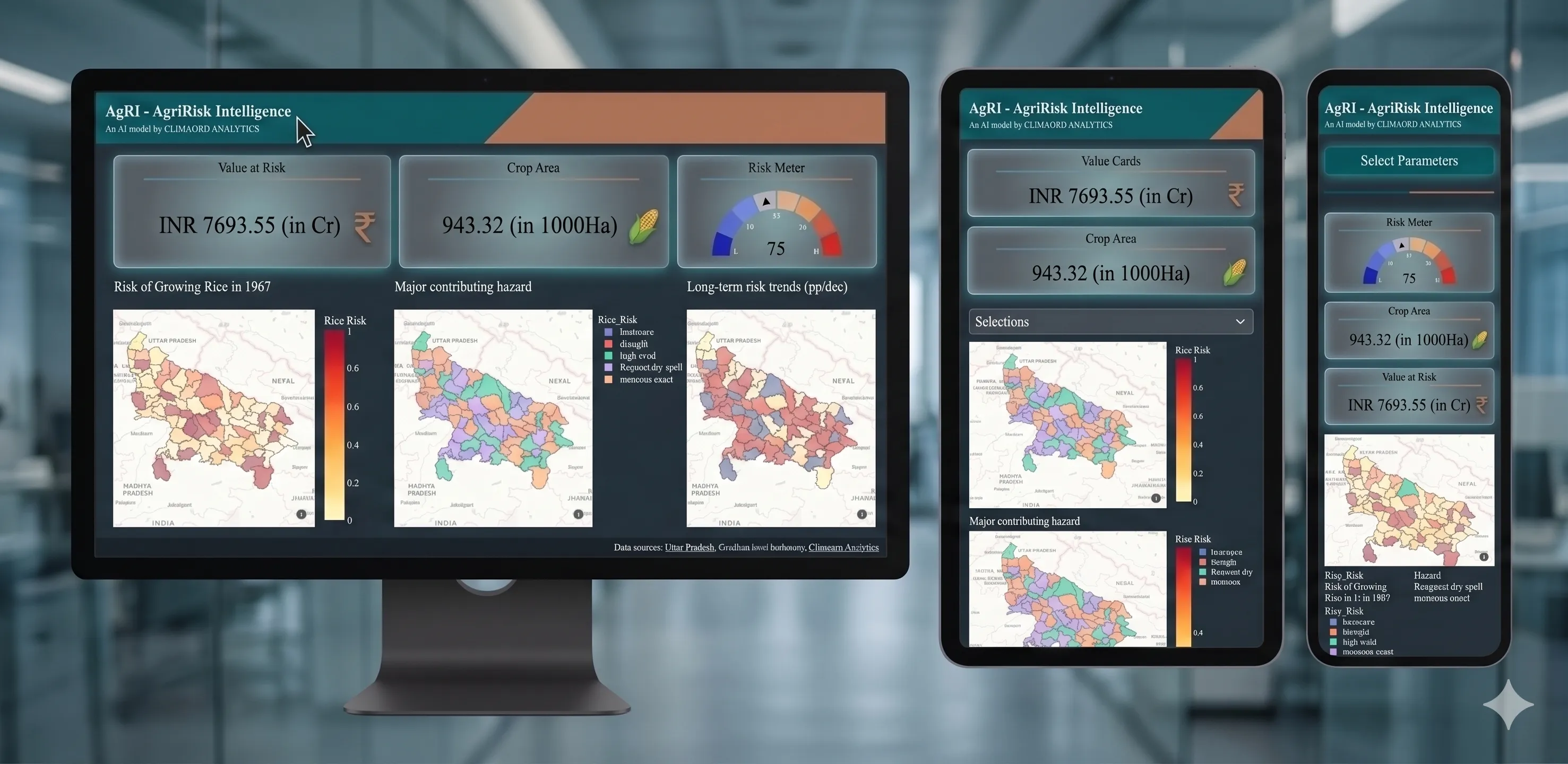
Risk Score & Classification
Crop and location-specific risk score from Low to Very High, with historical context and benchmarking against district averages.
Spatial Exposure Mapping
Map of crop area under each risk level, with identification of highest-exposure geographies within a portfolio.
Value at Risk & Expected Loss
Quantified financial exposure estimates - VaR and expected loss - enabling actuarial-grade risk pricing and provisioning.
Dominant Hazard Attribution
Identifies which climate hazard - drought, heat stress, excess rain, cold - is the primary driver of risk for each crop-location.
Short, Medium & Long-term
Risk projections at seasonal, decadal and centennial horizons across SSP1-2.6, SSP2-4.5, SSP3-7.0 and SSP5-8.5 scenarios.
Historical Risk Trends
Multi-decade analysis of how risk has evolved - variability, persistence, and emerging hotspots.
Yield Stability Index
Measures inter-annual yield variability to assess reliability of production under current and future climate conditions.
Crop Rotation Index
Evaluates alternative crops as a risk-management strategy, supporting evidence-based adaptation planning.
Portfolio Aggregation
Roll up district-level risks into state, regional or national portfolio views - designed for banks, insurers and agribusinesses.
Built for Every Stakeholder in the Agricultural Value Chain
Analysis-ready risk metrics formatted for immediate business integration.
Banks & Financial Institutions
Integrate agricultural climate risk into credit scoring, loan provisioning, and portfolio stress testing. Support BRSR and TNFD climate disclosure requirements.
Key Capabilities
-
✓Climate-informed agricultural lending
-
✓Portfolio-level crop risk exposure mapping
-
✓Expected loss estimates for provisioning
Insurance & Reinsurance
Develop risk-differentiated products and improve underwriting accuracy with granular, location-specific hazard data.
Key Capabilities
-
✓Parametric product design using hazard indices
-
✓Spatial risk mapping across insured areas
-
✓Long-term actuarial baseline for product pricing
Agribusinesses
Use CropRisk.ai to identify high-risk sourcing regions, forecast yields, optimise procurement, and strengthen contract negotiations.
Key Capabilities
-
✓Pre-harvest supply forecasting
-
✓Climate risk screening for sourcing geographies
-
✓Commodity price volatility risk assessment
Government Agencies
Support evidence-based policy formulation, agricultural subsidy targeting, and climate adaptation planning at state and district levels.
Key Capabilities
-
✓District-level crop vulnerability mapping
-
✓Identification of intervention hotspots
-
✓Scenario-based planning for climate adaptation
Seed Industry
Inform the development and positioning of climate-resilient crop varieties using forward-looking risk analytics.
Key Capabilities
-
✓Identify stress conditions driving variety demand
-
✓Map high-risk geographies for targeted deployment
-
✓Validate variety performance under future climates
Frequently asked
questions.
CropRisk.ai supports 20+ major crops including rice, wheat, maize, soybean, sugarcane, cotton, pulses, and several horticulture crops. Coverage is being expanded continuously. Contact us if you need a specific crop not listed.
Risk estimates are available at district level across India. Sub-district (block/tehsil) level data is available for select states and is being expanded. Point-level estimates are available on request for enterprise clients.
CropRisk.ai is not a weather forecast. It is a risk intelligence platform. It integrates multi-decadal climate data with crop-specific models to produce risk scores, financial loss estimates, and forward projections - outputs designed for business decision-making, not farm operations.
Yes. CropRisk.ai risk outputs can be delivered via API for integration into lending systems, insurance underwriting platforms, and commodity trading workflows. We support CSV, JSON, and standard geospatial formats.
Historical risk baselines are updated annually. Seasonal risk outlooks are updated at the start of each crop season. Future projections use the latest CMIP6 scenario outputs.